Презентація на тему:
Англо-американська суспільна географія: поняттєво-термінологічний апарат науки
Завантажити презентацію


, напрямок (Direction) т...")
 (fig 1....")


 - absolute and relative Відстань (D...")
 The population of the Twin Cities wa...")

 For example, site factors is used to locate the plac...")


 We can refer to the size of an area as local, reg...")


 – the area...")
 is the ...")


 Places constantly change! • ...")


 – determines a patte...")


 refers to the multiple connections from point to poin...")


 Regions have location (розміщення). 2) Regions hav...")
Англо-американська суспільна географія: поняттєво-термінологічний апарат науки
Завантажити презентаціюПрезентація по слайдам:

Тема 1 Англо-американська суспільна географія: поняттєво-термінологічний апарат Розміщення, місце та простір Просторова структура та взаємозв’язок місць Регіони
, напрямок (Direction) т...")
1. Розміщення, місце та простір Розміщення (Location), напрямок (Direction) та відстань (Distance) Місцеположення (Site/Situation) Розмір (Size) та масштаб (Scale) Місце (Place) та простір (Space) Природні та культурні характеристики (Physical and Cultural Attributes)
 (fig 1....")
Розміщення Absolute/Relative Location (Абсолютне/відносне розміщення) (fig 1.3) : - Absolute Location expresses the ‘mathematical’, exact location”. Absolute location is the identification of a place using a precise accepted system. All places are located on the surface of the earth, and their locations can be unambiguously identified using a number of spatial reference systems – latitude and longitude. Relative Location expresses spatial interconnection and interdependence, relation of any place to surrounding (other) places.

Fig. 1.3 For example, Hanoi, Vietnam, is located at 21 degrees north latitude and 106 degrees east longitude.

Абсолютне розміщення The absolute location usually has point form. Also – as area of the polygon, when latitude and longitude coordinates for all corners are determinate. Determination of the absolute location of an administrative area with irregular boundaries, such as Chile or Japan, would be difficult. Examples of absolute location are cadastral maps, those that clearly identify the dimensions and areal extent of land for legal purposes such as ownership. The land survey system that uses visible landscape reference points to delineate a land holding is the metes and bounds system.

Відносне розміщення The location of a place in relation to another place. Example – Mischief Reef – a tiny atoll in the South China Sea, that has strategic importance This seemingly insignificant island lies precisely along key sea-lanes that, among other things, are the delivery routes for virtually all of Japan’s crude oil. Mischief Reef lies within the hotly contested South China Sea, a body of water claimed in total by both Chinese governments and Vietnam to be their exclusive property. To add to the complexity of this geopolitical situation, the Philippines, located to the east of the Spratly Islands, claims ownership of that island complex, including Mischief Reef. Finally, there is strong evidence that petroleum and natural gas reserves are present in abundance in the seabed below the South China Sea.
 - absolute and relative Відстань (D...")
Напрямок та відстань Напрямок (Direction) - absolute and relative Відстань (Distance) - absolute and relative Absolute Direction refers to the cardinal points of the compass (North, South, East and West) Relative Direction refers to the relative aspects of direction and are locationally and culturally variable. For example, “Up North” - “Down South”, “Developed West” - “Wild East”. Absolute Distance refers to the spatial separation of two points as measured by some accepted standard unit (feet, miles / km). Relative Distance transforms linear measurements into something more meaningful (for example, time, money).
 The population of the Twin Cities wa...")
Абсолютна та відносна відстань (fig 1.4) The population of the Twin Cities was about 2.2 million, Duluth had about 75,000 population, and Chicago had more than 5 million. The number of nonstop scheduled airline flights between Chicago and the Twin Cities far exceeds the number of flights between the Twin Cities and Duluth. It may be concluded that Chicago, although it is farther from the Twin Cities in linear distance, is closer to the Twin Cities than Duluth if the measure of relative location. Fig. 1.4

Місцеположення Site refers to the physical characteristics and attributes of a place. Site is the physical features of a place that were important considerations in its initial selection as a settlement Situation refers to the external relations of a place. Situation considers the location of the place in reference to other physical and cultural attributes within its larger areal context Site represents a vertical location factor, situation – horizontal location factor
 For example, site factors is used to locate the plac...")
Місцеположення (fig 1.5) For example, site factors is used to locate the place on a navigable river. A situational factor is identified that the river location provides access to a local forest, connects the place with other settlements. Fig. 1.5

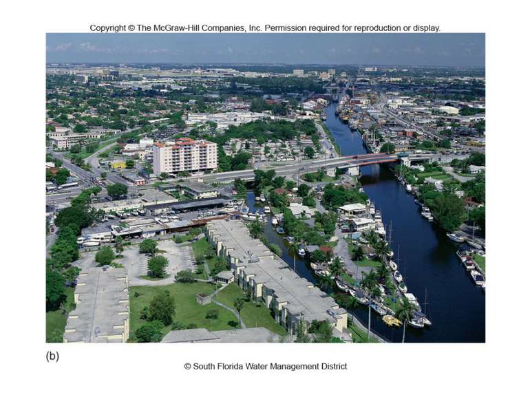
For example, the site factors for Chicago include the land on which it was built, close proximity to the southern end of Lake Michigan, and the presence of a river flowing through it. Chicago’s situation reflects the potential economic gain from commerce on Lake Michigan, the city’s access to rich agricultural land in Wisconsin and Illinois, and the city’s accessibility to other settlements within its immediate region and beyond by long-distance transportation systems. Місцеположення (fig 1.6) Site reflects the internal physical characteristics of the place. Situation reflects its external physical and cultural relationships of significance to the economic and social well-being of the settlement.

Fig. 1.6

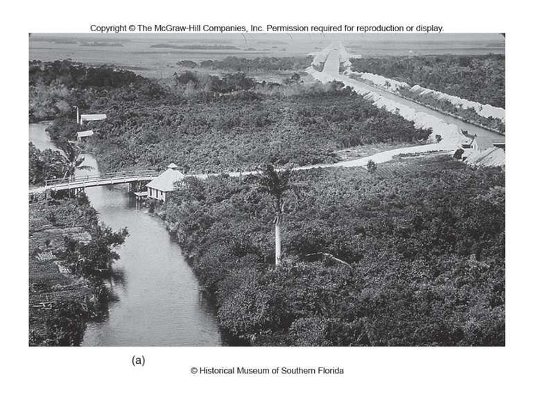
Site and situation factors may change in time. Site changes. The borough of Manhattan in New York City has been extended to the south a number of times to gain more land from the sea . Tokyo Bay is fast being filled in as the demand for more land. Situation changes. Only a few miles from Hong Kong, in China proper, is the city of Guangzhou. Over the years, this city benefited from its close proximity to Hong Kong, and its fortunes increased when Hong Kong reverted to Chinese control. Місцеположення
 We can refer to the size of an area as local, reg...")
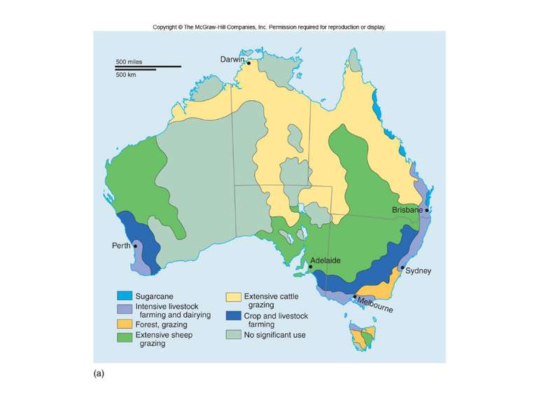
Розмір та масштаб (fig 1.7) We can refer to the size of an area as local, regional or global. Global scale – world economy Regional scale – economic activity in Southeast Asia Local scale – shops in a small town in Nebraska We can refer to scale in the relative sense as: Large scale – Small Areas, Greater Detail Small Scale – Large Areas, Little Detail Scale in cartography, however, refers to a precise measuring system. Scale in this sense is a way of stating the relationship between a distance or area measurement on a map and the actual dimension in the real world.

Fig. 1.7

Місце та простір Place is an environment in which people live and work. Place has both cultural and physical components. Cities, agricultural fields, countries, pizza parlors, and gold mines are all examples of places that geographers may choose to study. Space - абсолютний простір (absolute space) is used to define the physical dimensions of objects - відносний простір (relative space) is reflective of the actions and intentions of the person operating within it.
 – the area...")
Простір Relative space: - activity space (простір життєдіяльності) – the area within which people normal daily activities take place - personal space (особистий простір) – the space around the body of each person Public/private space (публічний/приватний простір) - public – space to which all citizens have a right of access, open to all – is the plaza, street or park - private – space over which private property rules are in operation (the right of owners to exclude others from the use and enjoyment of a space) - ‘semi-public’ spaces (напівпублічний простір), such as the airport or university
 is the ...")
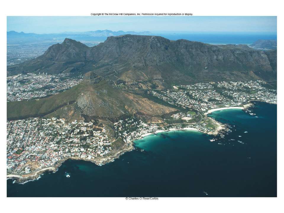
Природні та культурні атрибути Природний ландшафт (Natural landscape) is the physical environment unaffected by human activities (climate, soil, water, terrain) Культурний ландшафт (Cultural landscape) is the natural landscape as modified by human activities bearing the imprint of a culture group (fig 1.8). Also known as the Built Environment. Fig. 1.8

 Places constantly change! • ...")
Fig. 1.9 Атрибути місця, що змінюються (fig 1.9) Places constantly change! • Physical Changes (Glaciers) • Cultural Changes (People, Culture, Language, Religion)


Атрибути місця, що змінюються No place exists in and of itself. Places are affected by events occurring in other settings. For example, advancements in transportation technology have resulted in a kind of time-space compression (convergence), in places becoming closer to each other in terms of travel time and accessibility. Degree of accessibility between places has increased significantly. By horse – by airplane For example, in the 1830s a trip from New York City to San Francisco by the fastest surface transportation would take at least two months, today it could be made in a few days by train or automobile, or in a few hours by airplane.

2. Просторова структура та взаємозв’язок місць Просторове поширення (Spatial Distribution) Густота/Щільність (Density) Дисперсія (Dispersion) Патттерн/модель (Pattern) Просторова взаємодія (Spatial Interaction) Зв’язність (Connectivity) Доступність (Accessibility) Мережа (Network)

Просторове поширення The arrangement of things on the Earth’s surface is called Spatial Distribution (просторове поширення) which can be analyzed by the concepts of Density, Dispersion, Distribution Густота/Щільність (Density) – the number of items (objects, people) per unit area (within a defined area) Дисперсія (Dispersion) – the amount of spread of a phenomenon (clustered/agglomerated, dispersed/scattered) Паттерн (Pattern) – the arrangement of things in an area. Fig 1.10

Fig. 1.10
 – determines a patte...")
Просторова структура Аналіз паттернів (Pattern analysis) – determines a pattern’s structure: Однорідна структура (Uniform structure) – the arrangement is totally uniform (for example, regular spacing of fruit trees in an orchard or rows of corn on a flat agricultural field) Випадкова структура (Random structure) – the arrangement is completely random, with no observable order Аналіз найближчого сусідства (Nearest-neighbor analysis) – numeric procedure that assesses a single number within a set range across the continuum from random to uniform. The nearest-neighbor formula can be used to deter- mine the structure of any pattern in terms of its uniformity or randomness.

Places are interdependent; they do not function alone. The geographic term that reflects this interdependence is spatial interaction (просторова взаємодія). Spatial interaction assumes a system of places within which a degree of connectivity exists. The concept of connectivity (зв’язніcть) considers the many pathways (highways, air routes, sea-lanes, e-mail, fax, etc.) that allow interaction between distant points; all of the possible ways in which people and places are connected (fig 1.11). The concept of accessibility (доступність) determines the efficiency of these pathways. For instance, two points connected by one line would be less efficient than having the two points connected by two lines. Accessibility may be diminished for a period of time (if a storm is sufficiently severe, airports may be closed; the message “all lines are busy; please try again later” signals that accessibility is temporarily diminished). Взаємозв’язок місць

Fig. 1.11
 refers to the multiple connections from point to poin...")
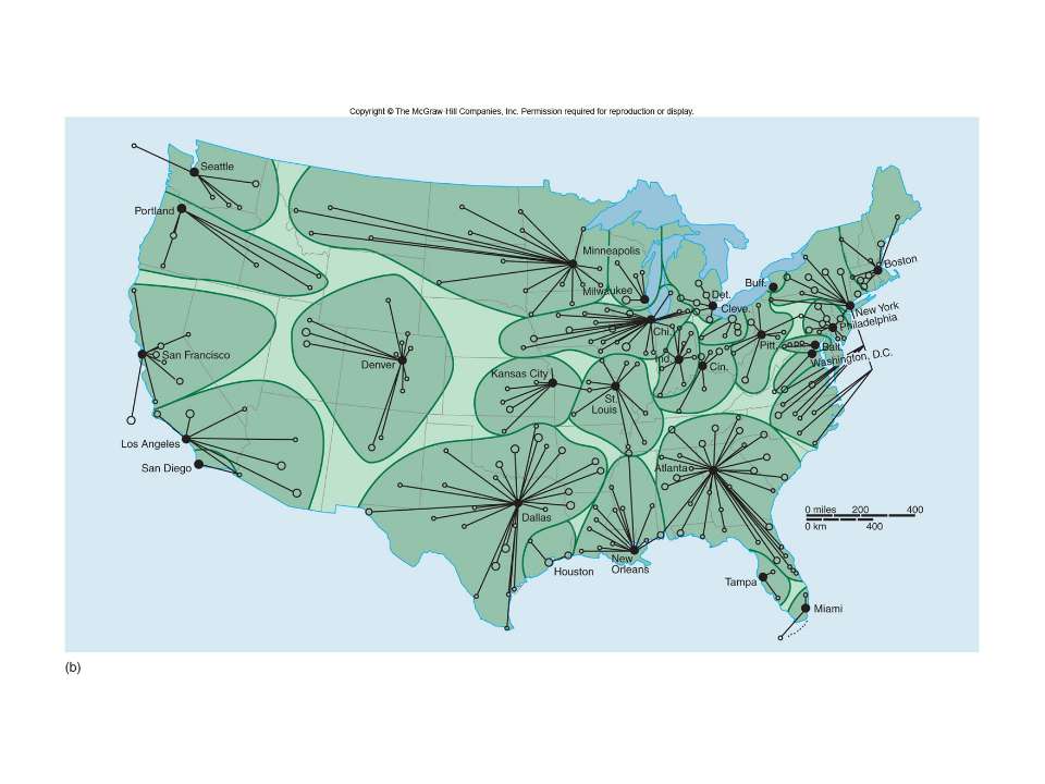
Мережа Network (мережа) refers to the multiple connections from point to point. Мережевий аналіз (Network analysis) includes: accessibility between and among points degree to which each point in the network is connected to all other points (connectivity) network completeness (повнота мережі) directional bias (відхилення напрямку) in the network (for instance, in the railroad system in the United States and Canada, the east–west lines are predominant in number and amount of traffic compared to the north–south lines) Network analysis extends from transportation to the vast and growing realm of electronic communications. Radio, television, and the Internet are examples of networks that can be analyzed and studied in terms of their spatial extent, degree of accessibility and connectivity, directorial bias, and concentration.

3. Регіони Geographers attempt to synthesize many phenomena to explain the whole and to organize places as regions. Region: (a) an area or zone of indeterminate size on the surface of the Earth, whose diverse elements form a functional association; (b) one such region as part of a system of regions covering the globe; (c) a portion of one feature of the Earth, as in a particular climate region or economic region

Типи регіонів The region represents one way of classifying information about places. Every discipline has its own classification systems, and geography is no exception. Types of regions: Формальний/однорідний регіон (Formal/uniform region): area that has uniformity in one or limited combination of physical or cultural features. E.g. county, state, nature zone Функціональний/вузловий (Functional/nodal region): area that defined by the connections and interactions of places, core and peripheral relationship between center and margins. E.g. store’s customer zone Перцепційний регіон (Perceptual region): area that reflects human spatial feelings and images, the cultural identities of individuals or groups. Such as “вернакулярний регіон” (“vernacular region”) that shows the way people view space, assign their loyalties and interpret their world. E.g. “Little Italy”, “Chinatown”... Fig 1.12 The formal and functional regions is based on the results of objective and possibly statistical analysis, the vernacular region has an emotional and perceptual origin.

Fig. 1.12

 Regions have location (розміщення). 2) Regions hav...")
Характеристики регіонів 1) Regions have location (розміщення). 2) Regions have spatial extent (просторові параметри). 3) Regions have boundaries (границі). 4) Regions are hierarchically arranged (ієрархічна впорядкованість).
Схожі презентації

 ТА ВПРОВАДЖЕННЯ ЇХНЬОГО...")


Категорії